When it comes to determining property lines for landlords or anyone involved in property management, having access to reliable programs for accurately demarcating property lines becomes crucial. Moreover, we also know building your dream home holds immense appeal, which is why we bring you the Best Home Decorating Games For Adults.
In this article, we introduce you to a selection of exceptional apps that are available for free download. These remarkable tools provide users with convenient access to property boundary data, offering valuable insights into potential properties.
1. LandGlide
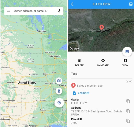
This highly acclaimed property boundaries application has gained immense popularity among homeowners, real estate experts, and land enthusiasts. One of its remarkable features is its user-friendly interface, which has contributed significantly to its widespread recognition.
Seamlessly navigating the application is effortless due to its impeccably designed arrangement and easily comprehensible symbols. Furthermore, the interactive map feature grants you the ability to effortlessly explore property boundaries. It may be either by inputting an address or utilizing the GPS capabilities of your device.
Additionally, it excels in providing you with precise property boundary information. By relying on trustworthy sources and incorporating the most current data, the application ensures the displayed property lines are characterized by unparalleled accuracy.
This level of accuracy holds the utmost significance for homeowners and real estate professionals who depend on precise property boundary details for numerous purposes, such as property development, fencing, and landscaping.
Moreover, apart from displaying property lines, the application offers a plethora of information concerning land parcels. You can easily access information about land ownership, zoning regulations, tax records, and legal descriptions.
This comprehensive approach simplifies the process of gathering all the essential property information. And it is in one convenient platform, saving both time and exertion.


You may also like: 9 Best Apps to Buy Land in Metaverse
2. The Regrid Property App
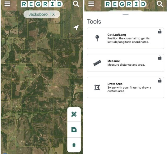
It is a powerful tool designed to assist property enthusiasts in conducting property research and analysis. With its comprehensive features and user-friendly interface, the app aims to streamline the process of gathering property data. Firstly, it boasts a clean and intuitive interface that makes it easy to navigate through its various features.
The great thing is its extensive property database. This wealth of data empowers one to make well-informed decisions based on accurate and up-to-date information. The app offers advanced search and filtering options. It allows you to narrow down their property search based on specific criteria.
Whether it is location, property type, price range, or other customizable parameters, you can refine their search results to find properties that match their requirements. The tool goes beyond property data by providing you with robust market analysis tools.
You can analyze market trends, track property values over time, and identify investment opportunities. The app offers charts, graphs, and data visualizations to help gain valuable insights into the real estate market.
The app supports collaboration and sharing features, making it convenient for real estate professionals to collaborate with clients, colleagues, and other stakeholders. Besides, you can share property information, reports, and market analysis findings easily through the app.
Also, it allows you to access property data and perform searches even without an internet connection. This feature is especially useful when conducting property research on the go or in areas with limited connectivity.


3. Google Maps
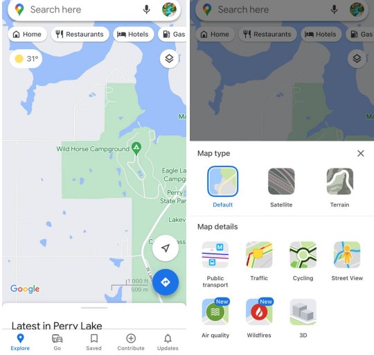
We also present Google Maps as an invaluable resource for determining property lines. With its access to high-quality satellite imagery and street views, Google Maps offers an immersive experience.
You can seamlessly switch between different map views, allowing for a comprehensive understanding of the property’s surroundings. This feature proves particularly beneficial when visualizing property lines and assessing neighboring structures or natural elements that may impact the property.
Additionally, Google Maps provides basic measurement tools, enabling users to gauge the distance between multiple points on the map. While these tools aren’t specifically tailored for measuring property boundaries, they offer a rough estimation of distances and assist users in approximating property size.
Furthermore, Google Maps seamlessly integrates with various platforms and services that provide property information. Users can utilize third-party real estate data services and overlay them onto Google Maps. It results in a more comprehensive view of property boundaries.
Additionally, users have the freedom to mark specific points of interest and draw shapes, facilitating efficient information sharing.


4. onX Hunt: GPS Hunting Maps
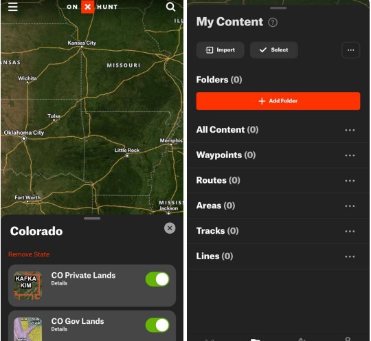
Originally developed as a specialized hunting application, this versatile app has found relevance as a powerful tool for determining property lines. With its strong emphasis on mapping and tracking, the app offers a unique perspective on exploring property boundaries and gathering pertinent information.
Its robust mapping features cater specifically to outdoor enthusiasts, providing highly detailed and accurate topographic maps, aerial imagery, and satellite views. These features prove invaluable for comprehending the terrain and surroundings of a property.
A notable highlight is its offline functionality, allowing users to download maps for offline use. This ensures that property data and mapping information remain accessible even in remote areas with limited internet connectivity. This is particularly advantageous when exploring properties in rural or wilderness locations.
While not designed exclusively for property lines, the app offers the capability to create custom markers and waypoints on the map. Users can mark essential locations, boundaries, and points of interest related to a property.
Users can visualize and estimate property lines within the app by inputting coordinates or markers manually. The app also provides tracking and navigation features, allowing users to record their movements, trails, and routes accurately.
Sharing functionality is facilitated through waypoint and track-sharing features, making it easy to share specific locations, property markers, or tracks with others. This promotes seamless communication and collaboration among property owners.


5. Parceled – Real Estate
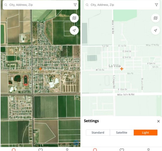
We introduce another exceptional application that offers an impressive range of features for individuals involved in property management. Firstly, this app boasts a user-friendly interface, ensuring effortless navigation for users. Its well-designed layout and intuitive tools make it accessible to anyone.
One of the standout aspects of this app is its ability to provide accurate and reliable data on property boundaries. Users can have full confidence in the precision of the displayed property lines, making it a dependable tool for property management. Moreover, this app goes beyond just displaying property lines.
It offers a wealth of additional information about land parcels, including crucial details such as land ownership, zoning information, and legal descriptions. This comprehensive approach allows users to gather all the necessary information about a property in one place, streamlining the management process. The app’s interactive map is truly remarkable.
With just a few taps, users can easily explore the boundaries of a property by searching for an address or utilizing the app’s GPS functionality. The map provides a visually appealing representation of the property, allowing users to gain a better understanding of its surroundings and neighboring structures.
To further enhance the user experience, the app offers additional tools and features. Users can create custom markers and annotations on the map, making it effortless to mark specific points of interest or delineate precise boundaries. This functionality greatly aids in organizing and managing property-related information.

You may also like: 11 Best Online Rent Collection Apps
6. GPS Fields Area Measure
It is another tool for measurement and management. It offers a comprehensive set of tools for accurate measurement and tracking of land areas.
Using GPS technology, the app precisely measures property areas by capturing and calculating GPS coordinates as users walk or drive around the land perimeter. This eliminates the need for manual measurements and ensures highly accurate results.
One great feature of the app is its versatility. It can measure not only simple rectangular plots but also properties with complex boundaries or irregular shapes.
Beyond land measurement, GPS Fields Area Measure offers additional functionalities such as project management, allowing users to organize and store measurements for different properties. It has custom labels, notes, and photos that can be added to specific areas on the map.
Besides, The app supports both metric and imperial units, accommodating users’ measurement system preferences. Exporting measurements and data in various formats enables easy sharing and further analysis.
A notable advantage is the app’s offline capability, enabling measurements and data recording in remote areas without internet access. This is particularly beneficial for users operating in rural or remote locations.


7. Acres: Land Data & Parcel Maps
If you require accurate information regarding land plot boundaries, area, and ownership, look no further than this indispensable application. Designed with a user-friendly interface, even novices can easily grasp its functionalities.
The app provides a comprehensive map and detailed data on land plots, allowing you to visualize plot boundaries, nearby roads, rivers, and natural landmarks. This facilitates easy navigation and spatial understanding.
Furthermore, the app offers invaluable information on land plot owners, along with additional details about areas, boundaries, and other pertinent factors crucial for buying or selling land. The application presents multiple viewing modes for maps and land plots, facilitating effortless measurements.
Additionally, the distance measurement feature enables you to determine the distances between plots. It’s worth highlighting that the app undergoes regular updates, ensuring the provision of up-to-date and reliable data about land parcels.
This is particularly important when making informed decisions regarding plot and property purchases or when in need of current data to address specific issues. Rest assured, with this application, you can confidently rely on the accuracy and timeliness of the information at hand.


8. Property Survey GPS
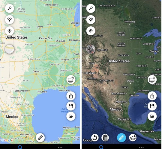
Utilizing advanced GPS technology, this application provides precise measurements and boundary information for your land area. Simply mark the boundaries of your plot using points, and the app will furnish you with detailed data. Notably, the app supports over 8 points on the map, enabling measurement of any plot’s area.
Alongside accurate measurements, the app offers useful GPS features to aid map navigation. You can thoroughly examine your plot and neighboring plots to understand boundary lines. The app allows you to save measurements within the application and directly share them. Exporting in KML and GeoJSON formats is also possible.
Furthermore, the app provides diverse map styles for enhanced area visualization. This application is perfect for individuals seeking to calculate the precise area of a new plot they are considering for purchase.

You may also like: 8 Best Apps to Check Room Temperature
9. Field Area & Maps Measure app
This exceptional application is designed to assist you in accurately measuring your land area and determining property boundaries. With its user-friendly interface and intuitive design, the app ensures a seamless experience as you locate and mark the boundaries of your property.
Utilizing advanced calculation algorithms, the app enables precise measurement of land area. By marking points on the map, you can easily create lines that instantly display the boundaries in real-time. With its clear visualization feature, the app provides a comprehensive view of your land, helping you gain better insights.
Additionally, you have the option to create customized markers and labels on the map, enabling you to highlight points of interest.
With real-time functionality, the app continually updates the boundaries and area as you mark points on the map, ensuring the most accurate results for your land area. Experience the convenience and accuracy of this app as you effortlessly manage your property boundaries.


