It is no secret that a tourist should learn how to navigate around. Over the past few years, it has become much easier to use a smartphone to navigate. Paper maps are not so relevant anymore. For this reason, we suggest you get acquainted with the best navigation apps on the water.
In today’s article, you will see programs with basic features and unique route features. In addition, we also offer services that will prevent terrible weather conditions. Read more in the article Best Hurricane Tracker Apps.
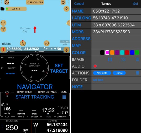
1. Compass 55. Map & GPS kit.
This is a very simple program that will suit most people. It has a minimum of complex, but advanced settings for water sports and tourism. It also provides you with a mobile device in a user-friendly way with up-to-date marine charts. Also, it has universal coordinates for viewing and sharing in several formats.
Also, there are standard metrics such as elevation and distance. In addition, you can view sunrises and sunsets. In addition, you can even plot a route that is important to you. Moreover, you do not need to worry about the fact that you will not be able to use the application without the Internet.
After all, all maps are saved on your smartphone and are available offline. In addition, you can write down important points in the route, adding for example a short description and a photo. Some users use these points as a special guide, for example in places where there is no internet or GPS.
There are also third-party features, such as a night vision map or a 3D model map. The creators of the application also claim that the application is useful not only in open water areas but also when driving. There is a special function for this purpose.

You may also like: 7 Best Wind Radar Apps
2. i-Boating: Marine Charts & Gps
This app contains navigation maps for inland rivers and several maps to help you determine the route to your boat. The app is very easy to use and has custom functionality. There are many settings in the app, one of them is to show the depth of the river or sea where you are. By pointing your finger at the cursive you will be able to see the exact depth.
Also, you can see the following things near you with navigation: lighthouses, boat launching areas, boat ramps, and fishing rides, and much more. In addition, when you set the navigation point, the application prompts you with voice guidance as to where you need to go.
It is worth mentioning that the app works offline and you can use the full functionality of the app without accessing the Internet. Besides, the app displays the predicted path, speed, and direction in which you need to move. In addition, it gives you information about possible tides and predicts tidal currents and active current stations.


3. Commander Compass Go
This application provides you with GPS navigation so that you can orientate yourself at sea and navigate your way forward. The application is equipped with many functions, one of which is the compass. You will be able to increase the accuracy methods and use special compass modes and calibration methods to navigate over the terrain.
Also, the application works in 3D graphics, thanks to which you will be able to see the position of objects, information, and direction to them. You can also add points to the map and manually drive location coordinates and azimuths.
In addition, the application allows you to share your location, coordinates, and links to the map using the many permissions that the platform supports. In addition, the app remembers your location and the path you have taken, so at the end of your travel, you can get detailed information about your journey.

4. iNavX: Marine Navigation
This application is one of the most well-known navigation applications and supports free raster maps. In addition, you can download several other maps. Moreover, many users give great reviews about yachting when using this app.
So, the app will suggest you save the maps in simple tables. Tables are grouped by region. After that, the map you choose displays your position in real time. You can also pan and zoom in and out. However, it is possible to select the scale of the map that suits you.
All you have to do is to go back to the menu and select the appropriate scale. In addition, it has a special weather forecast as well as a tidal and flow forecast. The app is also famous for its comprehensive set of features, which is suitable for advanced users.
In addition, you can even plan your route well here, and even import waypoints. Furthermore, there is NMEA data mapping here. On top of that, there is also an intuitive interface with maps understandable to experienced boaters.

5. MarineTraffic – Ship Tracking
This app will help you track ships in real-time and get detailed information about every single ship you meet. The app uses AIS to help you easily get information on more than 100,000 ships per day. When you enter the app, you look at a GPS navigation map. This allows you to track vessels that are near you.
Also, each vessel is color-coded so that you can identify the type of vessel. In addition, the application provides you with animated playback of each ship so you can see where they are heading. You can also view the ports of arrival and departure in real-time.
More than 4,000 ports and berths are marked on the map and by clicking on a port or a berth you can see the approximate time of arrival of boats and ships. In addition, the app allows you to identify ships around you using the augmented reality tool.
By pointing your camera at a vessel, the app will give you information such as the name, flag, speed, distance from you, and many other things. The app also includes basic navigation functionality.
You may also like: 11 Best Mountain Biking Apps
6. SeaNav
This application combines all the essential features and styles of popular applications. It allows the active user to plan and navigate using NOAA and UKHO vector maps. The app has a rich set of features and maps compared to other programs. All this makes sailing more convenient and pleasant. In addition, the maps automatically load as you scroll.
On top of that, there is a display that includes satellite or hybrid maps. By tapping on the map, you can explore objects such as buoys, lights, and bridges. Besides, you can search for a place with its exact coordinates. The app also shows a live camera view from buoys and ships, including their names, or range.
So the map allows you to make, and change your route plan on a familiar sea map. Any tap on the map will give you instant information about any object or place. You can also track sunrises and sunsets to better plan your route. In addition, there is a special wind indicator, without which it is impossible to travel.

7. Nautics Sailmate
A peaceful journey can also be provided by this app. Try to enjoy all its benefits. However, it is quite basic, which for some users especially beginners will be more of a positive feature. In addition, the main difference of this app is that it presents official sea maps with the ability to zoom in for more comfortable viewing.
Moreover, you can set your waypoints to plan your trip more wisely. It is also not without special notes that you can keep in the settings of the application.
Moreover, this application is suitable for any water sports and tourism. Meanwhile, the app tries to support the navigator by providing all possible information about the services with contact information around him. And this free application provides not only a basic map but also satellite shots, which will be useful for all travelers.

8. OnCourse – boating & sailing
This app allows you to improve your experience at sea and provides you with a navigational aid to help you navigate at sea. When you enter the app, you see a navigation map. It allows you to calculate and control your journey. The app also allows you to add your waypoints on the map.
When you build a route, the app will give you information about your speed, how long it will take you to get to the point, and much more. You can also share your location with your friends through a live animated map. In addition, the application uses AIS, which allows you to identify other ships that are near you.
In addition, the app allows you to interact with the community of other boaters. You will be able to chat, upload photos and share your location. Besides, you may identify boats and get detailed information just by pointing your camera at a boat near you.

You may also like: the 11 Best Parcel Tracking Apps
9. Navily
This is a unique guide to Europe that many services offer for shipping. Moreover, the app supports several languages in addition to English, such as French, Spanish, German and Italian. Like all maritime apps, it has the main feature.
For example, there are quite detailed descriptions of anchorages, marinas, availability of information about ways of protection from wind, types of anchoring, and much more. In addition, there are even reviews and photos to help you make decisions based on other users’ reviews.
Also, there is a special community here that is just as interested in marine travel as you are. And there’s a unique marina booking process available in several countries. Moreover, it is available to ordinary users who know little about technology.
In addition, you can even calculate the cost per night for your boat at any time of the year. The users also note the ability to contact customer service 24 hours a day directly from the application. In addition, the app has detailed routes for your next trips.